ARGOS ATLAS for Drone Operators: Research Your Job Site Before You Fly
By DJI Gear Portal — Affiliate Blog
A commercial drone job often begins long before the drone leaves its case. Whether you're preparing for a roof inspection, construction progress survey, infrastructure inspection, mapping project, or another aerial job, understanding the area around the work site can make your preparation more thorough.
That's where ARGOS ATLAS can be an interesting addition to a drone operator's research toolkit.
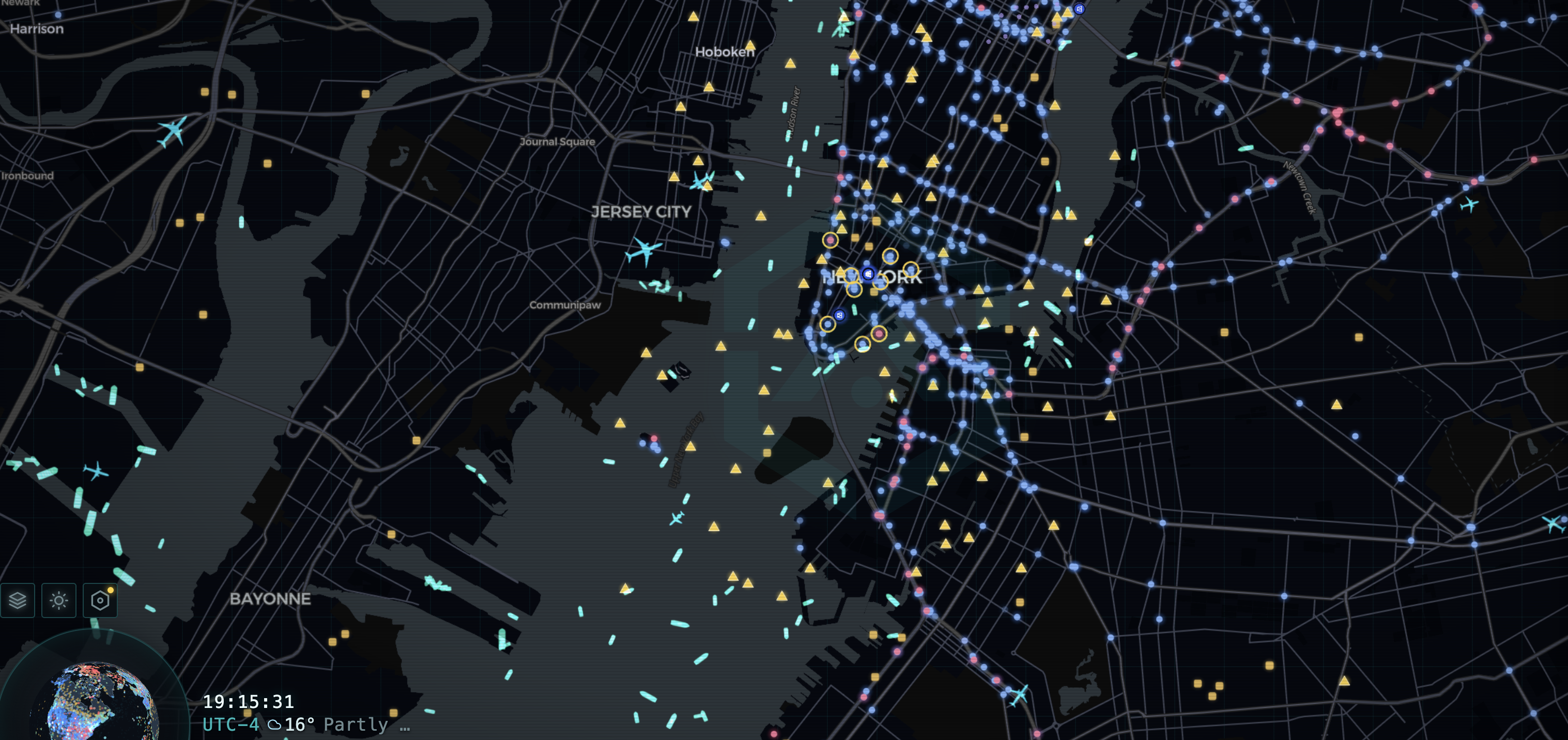
ARGOS ATLAS is a browser-based global map that brings together information from a variety of public and open sources — public traffic cameras, aircraft, ships, airports, ports, power plants, events, and other geographic information, all in one interactive view.
The important distinction: ARGOS ATLAS is not a replacement for the FAA, B4UFLY, LAANC, or any official airspace authorization system. Think of it as an additional research and situational-awareness tool that can help you understand the area around a job site — not a substitute for your legal pre-flight requirements.
Why Would a Drone Operator Need Another Map?
Commercial drone operators already have access to mapping applications, aeronautical charts, weather services, and official FAA airspace resources. So why look at another platform?
The difference is that ARGOS ATLAS puts many different types of information into one geographic interface. Instead of checking one site for traffic cameras, another for aircraft, another for ships, and another for general geography, an operator can use a single map to build a broader picture of the surrounding area — particularly useful when you're preparing for a job in an unfamiliar location.
1. Research the Area Before You Arrive
Imagine a client has hired you to photograph a commercial property several hours from your home base. You know the address and the scope of work, but you've never visited the area.
Before leaving, you could use ARGOS ATLAS to look at the surrounding area and pull together information that helps you understand the location:
- Nearby roads and traffic activity
- Public cameras where available
- Airports and aerodromes
- Nearby ports or waterways
- Power facilities and other mapped infrastructure
- Aircraft activity displayed on the map
- Ships and maritime activity in coastal or port areas
- Other geographic context surrounding the site
This doesn't replace a proper site survey. It simply gives you another source of information before you arrive.
2. Look at Aircraft Activity
One of the more interesting layers for drone operators is the aircraft view. ARGOS ATLAS displays aircraft using ADS-B data, including position, altitude, speed, and heading when that information is available.
For a drone operator, seeing aircraft activity around a location can provide useful context about how active the surrounding airspace appears to be.
Important: Aircraft shown on ARGOS ATLAS should never be treated as a legal determination that a drone flight is permitted. Part 107 operators must use B4UFLY, LAANC, and official FAA airspace resources to determine where and how they may legally operate — this map is context, not authorization.
3. Check Public Cameras Around the Job Area
ARGOS ATLAS also aggregates public traffic cameras and other public webcams from official portals. This can be useful when preparing to visit an unfamiliar area — a public road camera may provide additional context about traffic or conditions around an approach to a job site.
For a drone business, this can be particularly useful for work involving large commercial properties, industrial areas, transportation corridors, or waterfront locations.
4. Waterfront, Port, and Maritime Jobs
Not every drone job takes place beside a road. Construction sites, bridges, industrial facilities, ports, marinas, and waterfront properties can all require aerial imagery.
ARGOS ATLAS includes a maritime layer using AIS data to display ships and their reported positions. For an operator working around a busy waterfront, having a geographic view of surrounding maritime activity may provide useful situational context while researching the assignment.
Again, this is information for planning and awareness — not a substitute for the operator's legal responsibilities or an on-site assessment.
5. See Infrastructure on the Map
The platform includes mapped infrastructure such as power plants, airports, and ports, along with other geographic information. For someone researching an industrial inspection, construction project, or infrastructure-related assignment, seeing these features on the same map as other layers can help build a broader picture of the area.
It's worth remembering that the presence of infrastructure on a map doesn't automatically mean a drone operator has permission to fly over or around it.
6. A Practical Example: Preparing for a Roof Inspection
Say a roofing company hires a drone operator to document a large commercial building. Before driving to the property, the operator could research the location using several different sources.
ARGOS ATLAS could provide additional context by showing the surrounding roads, public cameras where available, nearby airports, aircraft activity, infrastructure, and other geographic information — giving the operator a better understanding of the general environment before ever arriving on site.
Once on site, the operator still needs to perform the required survey, inspect the actual launch and operating area, identify obstacles, and confirm the planned operation complies with FAA Part 107 rules and any required airspace authorization.
7. ARGOS ATLAS Is a Research Tool — Not a Flight Authorization System
This distinction is worth repeating. A live map can show a tremendous amount of information, but it does not give you permission to operate a drone.
In the US, Part 107 pilots are required to check controlled airspace, TFRs, and any local restrictions through official FAA channels — B4UFLY, LAANC, and the FAA's own airspace resources — before every flight. Those official resources should remain a non-negotiable part of your flight-planning process.
A useful way to think about it: use official FAA resources to determine the rules and permissions for your flight, and use additional research tools like ARGOS ATLAS to understand more about the environment surrounding your assignment.
8. Free ARGOS ATLAS vs. PRO
The live ARGOS ATLAS map is currently available without an account, making it easy to explore before deciding whether you need more. ARGOS also offers PRO plans with expanded camera access, AI analysis, historical data, and other features depending on the plan.
For a drone operator who only needs to research a job site occasionally, the free map may be enough. Operators who regularly do research-heavy work may find the paid tiers more useful.
Could ARGOS ATLAS Become Part of Your Drone Workflow?
A professional drone workflow involves much more than choosing a drone and pressing takeoff. Research, client requirements, weather, airspace, site conditions, obstacles, people, aircraft, permissions, and documentation can all be part of preparing for a commercial operation.
ARGOS ATLAS doesn't replace those responsibilities. What it can provide is another window into the environment around the location you're researching — useful for operators who regularly travel to unfamiliar job sites, inspect infrastructure, work around transportation corridors, or operate near ports and industrial areas.
Explore ARGOS ATLAS →Note: This is not currently an affiliate link.
Final Thoughts
Drone operators already have plenty of tools for maps, weather, airspace, and flight planning. ARGOS ATLAS is interesting because it approaches the problem from a broader angle — putting many different types of publicly available information onto one geographic interface.
If you operate commercially, it may be worth adding ARGOS ATLAS to your pre-job research process and seeing whether the additional information helps you understand unfamiliar locations before you arrive.
Just remember: situational awareness is only one part of a safe drone operation. Always follow FAA Part 107 rules, required airspace authorizations, and official flight-planning guidance for your location.
Related Guides
Best DJI Drones 2026: Complete Comparison Guide →
Best Beginner Drone Starter Kits 2026 →
Information checked for this article in September 2026. Always verify current FAA rules and requirements before conducting a drone operation.