When disaster strikes—whether from hurricanes, earthquakes, floods, wildfires, or other emergencies—every minute counts. First responders need accurate information quickly to save lives and coordinate relief efforts. DJI drones have become essential tools for disaster response teams, providing aerial views of affected areas, helping locate survivors, assessing damage, and supporting recovery operations in ways that were impossible just a few years ago.
The immediate aftermath of a disaster is chaotic. Roads may be blocked, communication systems might be down, and the full extent of the damage isn't clear. Emergency management teams need to understand what happened, where help is needed most urgently, and how to deploy limited resources effectively. Traditional methods of gathering this information—sending out ground teams, waiting for helicopter overflights, or relying on scattered reports—take too much time when lives hang in the balance.
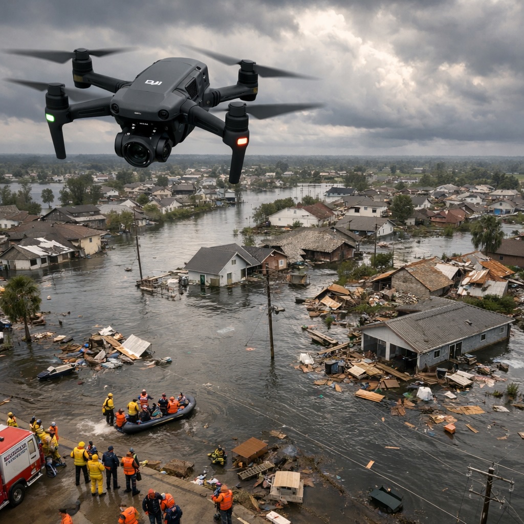
Drones change this equation dramatically. Within minutes of arriving at a disaster scene, response teams can launch a drone to survey the area. The aerial view immediately reveals blocked roads, damaged structures, areas of flooding, and where people might be trapped or stranded. This bird's eye perspective helps incident commanders make informed decisions about where to send rescue teams, how to route supplies, and which areas face the most urgent need.
The speed of deployment matters enormously. A drone can be in the air providing useful intelligence while traditional aerial assets like helicopters are still being coordinated and dispatched. For volunteer search and rescue teams arriving at a scene, a drone provides immediate situational awareness that helps them work safely and effectively.
Finding people who need help is the top priority in disaster response. Drones equipped with high-resolution cameras and thermal imaging can search large areas quickly, spotting people on rooftops, in isolated areas, or trapped in locations that ground teams might miss. The thermal cameras are particularly valuable because they can detect body heat even in darkness, through smoke, or in conditions where visual identification is difficult.
During flood events, drones can identify people stranded on rooftops or high ground, providing exact GPS coordinates to rescue teams. After earthquakes or building collapses, aerial views help identify areas where survivors might be located and the safest approach routes for rescue workers. In wildfire situations, drones can locate people cut off by flames and help direct them toward safe evacuation routes.
The drones don't replace ground-based search and rescue operations but make them more efficient and effective. Rather than searching blindly, rescue teams can be directed to specific locations where the drone has identified people or areas of concern. This focused approach saves precious time and increases the likelihood of successful rescues.
Understanding the full scope of disaster damage is essential for effective response and recovery. Insurance companies, government agencies, property owners, and relief organizations all need accurate assessments to allocate resources, process claims, and plan reconstruction efforts. Traditionally, this meant sending inspectors to physically examine every affected property and structure—a process that could take weeks or months after a major disaster.
Drones make comprehensive damage assessment possible in days rather than weeks. They can photograph entire neighborhoods, industrial facilities, or infrastructure systems from above, documenting the condition of every structure. The high-resolution imagery captures details that help determine whether buildings are safe to enter, which structures sustained the most damage, and where reconstruction efforts should focus.
This rapid assessment has practical benefits at every level. Homeowners get faster insurance settlements. Municipalities can prioritize which areas need immediate attention. Relief organizations can target their assistance to those most affected. The comprehensive visual record also provides valuable documentation for disaster declarations, insurance claims, and future mitigation planning.
Disasters often damage critical infrastructure like bridges, roads, power lines, water systems, and communication towers. Before these systems can be safely used or repaired, they need to be inspected for damage. This traditionally required putting workers in dangerous situations—climbing damaged towers, walking on potentially unstable bridges, or accessing flood-damaged facilities.
Drones perform these inspections without risking human lives. They can closely examine bridge supports, inspect power lines for damage, check the integrity of water treatment facilities, and assess the condition of damaged buildings from every angle. The detailed imagery helps engineers determine what repairs are needed and prioritize the restoration of critical services.
The speed of these inspections accelerates recovery. Power companies can quickly identify all the damage to their distribution systems and dispatch repair crews efficiently. Transportation departments can determine which roads and bridges are safe for emergency vehicles. This rapid infrastructure assessment helps communities begin the recovery process sooner.
Emergency management agencies, fire departments, search and rescue teams, and disaster response organizations are increasingly integrating drones into their operations. DJI provides reliable, professional-grade drones built to perform in demanding conditions when lives depend on the technology working correctly.
See DJI Enterprise SolutionsLarge-scale disasters involve numerous organizations working together—local emergency services, state and federal agencies, volunteer groups, military units, and private contractors. Coordinating all these efforts requires good communication and shared understanding of the situation. Aerial imagery from drones provides a common operating picture that all responding organizations can reference.
Incident command posts use drone footage to brief incoming teams, plan operations, and track progress. The visual information is easier to understand than verbal descriptions and helps prevent confusion about locations, conditions, and priorities. When a picture truly is worth a thousand words, drone imagery becomes an invaluable communication tool.
As recovery operations continue over days or weeks, regular drone surveys document progress and identify emerging needs. Areas that were inaccessible initially might become reachable as debris is cleared. New problems might emerge as temporary fixes fail or conditions change. Ongoing aerial monitoring helps keep response efforts aligned with evolving conditions.
Disaster recovery extends far beyond the initial emergency response. Communities spend months or years rebuilding infrastructure, reconstructing homes and businesses, and restoring normal life. Drones continue providing value throughout this recovery period.
Construction progress monitoring helps ensure that rebuilding efforts proceed on schedule and according to plans. Aerial surveys document how recovery funds are being spent and demonstrate progress to stakeholders and funding sources. Environmental monitoring tracks issues like erosion, contamination, or habitat damage that might affect recovery efforts.
The baseline documentation that drones provide immediately after a disaster becomes valuable reference material throughout recovery. Comparing current conditions to post-disaster imagery shows how far the recovery has progressed and what work remains. This visual record helps maintain focus and momentum on long-term recovery goals.
The most effective use of drones in disaster response comes from teams that have trained with the technology before disasters occur. Emergency services that regularly practice drone operations, develop standard procedures, and train personnel in aerial intelligence gathering will respond more effectively when real disasters happen.
Many emergency management agencies now include drone operations in their disaster preparedness training. Exercises and drills incorporate aerial reconnaissance as a standard capability. Operators practice flying in challenging conditions, processing and sharing imagery quickly, and integrating drone intelligence into decision-making processes.
This preparation ensures that when disaster strikes, drone operations happen smoothly rather than adding to the chaos. Trained operators know how to deploy quickly, gather useful information efficiently, and communicate their findings effectively to decision-makers who need the intelligence.
While drones provide enormous value in disaster response, they're not without limitations. Weather conditions that often accompany disasters—high winds, heavy rain, poor visibility—can make flying difficult or impossible. Battery life limits flight time, requiring careful planning and sufficient spare batteries for extended operations. Damaged infrastructure might affect GPS signals or communication systems that drones rely on.
Regulatory considerations also matter. During major disasters, airspace can become congested with emergency aircraft, news helicopters, and other drones. Coordination is essential to prevent conflicts and ensure safety. Professional response teams work with aviation authorities to ensure their operations don't interfere with other critical aerial activities.
Despite these challenges, the benefits of drone technology in disaster response far outweigh the limitations. As the technology improves and response teams gain more experience, drones are becoming an indispensable tool for protecting lives and accelerating recovery.
Disaster response drones have proven their value in real-world situations around the globe. After hurricanes, they've helped rescue teams locate survivors and assess damage across vast affected areas. Following earthquakes, they've identified structural damage and located people trapped in collapsed buildings. During floods, they've mapped inundation areas and guided rescue boats to stranded individuals. In wildfire situations, they've provided firefighters with situational awareness and helped coordinate evacuation efforts.
These aren't theoretical applications but demonstrated capabilities that have saved lives and improved disaster response outcomes. Emergency management professionals who've used drones in actual disaster responses consistently report that the technology has become essential to their operations.
As drone technology advances, its role in disaster response will expand. Improved battery life will enable longer missions. Better sensors will provide more detailed information. Artificial intelligence will help automatically identify areas of concern in imagery, speeding up analysis. We may see drones that can operate autonomously in disaster zones, providing continuous monitoring without requiring constant human control.
For emergency management agencies, fire departments, search and rescue organizations, and disaster relief groups, integrating drone capabilities is no longer optional but essential. The technology has proven itself as a life-saving tool that improves response effectiveness and accelerates community recovery. Having this capability ready to deploy when disaster strikes can make the difference between chaos and coordinated response, between delayed assistance and timely rescue.