When property damage occurs from storms, fires, accidents, or other events, property owners need their insurance claims processed quickly so they can begin repairs and return to normal life. Insurance companies need accurate damage assessments to settle claims fairly. Traditional inspection methods can create delays that frustrate everyone involved. DJI drones are transforming property damage assessment, making the process faster, safer, and more thorough while improving accuracy and reducing costs for insurance companies and faster settlements for policyholders.
The standard property damage claim follows a familiar but often slow pattern. After damage occurs, the policyholder reports the claim. The insurance company assigns an adjuster who schedules a site visit. The adjuster travels to the property, inspects the damage, takes photographs, makes notes, and creates measurements. For roof damage, this might require climbing ladders or accessing dangerous areas. For large properties or widespread damage, the inspection could take hours or require multiple visits.
After completing the inspection, the adjuster returns to the office to write up the assessment, calculate repair costs, and process the claim through various approval steps. This entire cycle typically takes days or weeks, during which the property owner waits anxiously for approval to begin repairs. In disaster situations affecting many properties at once, the backlog can stretch to months as adjusters work through overwhelming caseloads.
The process has other limitations too. Adjusters might miss damage that's difficult to see from the ground or dangerous to access. Weather conditions might prevent thorough inspections. Documentation quality varies depending on the adjuster's experience and the challenges of the specific site. These issues can lead to disputes about the extent of damage, delayed settlements, and dissatisfied customers.
A drone-equipped insurance adjuster arrives at a damaged property and launches the aircraft within minutes. The drone flies over and around the structure, capturing high-resolution photos and video of all damaged areas from multiple angles. Roof damage that would require climbing and walking on potentially unstable surfaces is documented thoroughly from the air. Large properties are surveyed comprehensively in a fraction of the time ground inspection would require.
The resulting imagery provides detailed documentation of all visible damage. Zoom capabilities let adjusters examine damage closely without physical access. Multiple angles ensure nothing is missed. GPS tags on every image precisely locate each damaged area. This comprehensive visual record supports accurate damage assessment and creates clear documentation for the claim file.
The time savings are significant. What might take hours of careful climbing and documentation from ladders can be completed in 15 to 30 minutes of drone flight. The adjuster processes more claims per day, policyholders get faster service, and the insurance company handles claims more efficiently. Everyone benefits from the improved process.
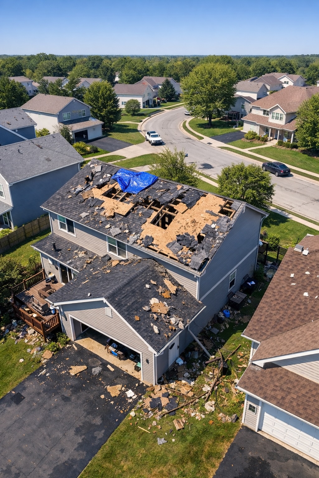
Roof damage represents one of the most common and challenging types of property claims. Traditional assessment requires adjusters to climb onto roofs to examine damage, a process that's time-consuming, potentially dangerous, and sometimes impossible when roofs are unstable after damage. Drones eliminate these challenges while providing better documentation than ground-based inspection.
A drone captures the entire roof surface in detail, documenting every damaged shingle, area of impact, and section needing repair. The overhead perspective shows damage patterns that help determine what caused the damage and how extensive repairs need to be. Close-up views reveal details about individual damaged areas. This comprehensive documentation supports accurate repair estimates and reduces disputes about the scope of necessary work.
For older roofs where the question isn't just about recent damage but about overall condition and remaining useful life, drone imagery provides clear evidence. The adjuster can examine wear patterns, existing deterioration, and how recent damage relates to pre-existing conditions. This documentation helps make fair determinations about what damage is covered by the current claim versus normal wear and tear.
After major storms, hurricanes, or other widespread disasters, insurance companies face enormous numbers of claims in affected areas. The challenge of deploying enough adjusters to handle the surge and completing inspections quickly seems overwhelming. Drones help address this crisis by enabling adjusters to assess more properties per day and document conditions before additional weather or deterioration complicates damage assessment.
In disaster zones, some properties might be difficult or dangerous to access immediately after the event. Downed power lines, flooding, debris, or structural instability can prevent or delay ground-based inspection. Drones can safely assess these properties from the air, providing initial damage documentation even when ground access isn't possible. This quick assessment helps prioritize response, identify properties needing urgent attention, and begin the claims process before full ground access becomes available.
The comprehensive aerial documentation also helps with fraud prevention. After major disasters, some unscrupulous contractors or property owners might inflate damage claims or attribute pre-existing damage to the recent event. Detailed drone imagery captured shortly after the event provides clear evidence of actual damage that supports legitimate claims while protecting insurers from fraudulent ones.
Commercial properties present additional challenges for damage assessment. Large buildings, extensive roof areas, complex structures, and varied property uses make thorough inspection time-consuming and difficult. Business interruption adds urgency—the property owner needs to resume operations as quickly as possible, which requires fast claim settlement so repairs can begin.
Drones excel at commercial property assessment. They can survey large roof areas systematically, document damage to building facades and exterior equipment, assess grounds and parking areas, and create comprehensive records of entire facilities efficiently. A commercial property that might take a full day or more to inspect thoroughly using traditional methods can be documented by drone in a few hours, including processing and organizing the imagery.
For commercial property owners, faster assessment means faster repairs and quicker return to business. The detailed documentation also provides clear evidence supporting business interruption claims by showing the extent of damage and why operations needed to cease during repairs.
Insurance companies, independent adjusters, and property assessment firms are rapidly adopting drone technology for claims processing. DJI provides reliable professional drones that deliver the image quality and flight stability needed for thorough property damage documentation in various conditions.
Explore DJI Claims SolutionsBeyond speed, drones improve the accuracy of damage assessments. The comprehensive photographic record captures details that might be missed during ground inspection. Multiple angles provide better understanding of damage extent and causes. The ability to examine images carefully after the site visit, zooming in on details and comparing different views, supports more accurate damage evaluation than what's possible during a time-limited site visit with only visual observation and quick notes.
The visual documentation also protects all parties in disputes. If questions arise about the damage assessment, the complete photographic record provides objective evidence of conditions at the time of inspection. This reduces misunderstandings and supports fair resolution of disagreements about damage extent or appropriate repairs.
For complex claims involving multiple types of damage or questions about causation, the detailed imagery can be shared with specialists, engineers, or other experts who can provide input on technical aspects of the damage without requiring separate site visits. This collaborative approach to complex claims improves outcomes while containing costs.
The safety advantages of drone inspections matter enormously in the insurance industry. Adjusters no longer need to climb on damaged roofs that might be unstable. They don't need to access dangerous locations to document damage. They can assess properties in hazardous conditions—after fires, in areas with downed power lines, or on properties with structural concerns—without putting themselves at risk.
This improved safety protects adjusters from injury while also reducing liability for insurance companies. Workers' compensation claims from injured adjusters decrease. The risks associated with asking employees to access dangerous properties are eliminated. Everyone works in safer conditions while still accomplishing thorough damage assessment.
For policyholders dealing with property damage, the claims process can be stressful. They want their claims handled quickly so they can begin repairs and return to normal life. Drone assessments contribute to faster claim processing, which directly improves customer satisfaction. Claims that might take weeks to process using traditional methods can be settled in days when drone documentation speeds the assessment phase.
The thorough documentation also benefits policyholders by ensuring all damage is identified and included in the settlement. Nothing gets missed because it was difficult to access or observe from the ground. The comprehensive record supports fair settlements that fully cover necessary repairs.
Policyholders also appreciate seeing the documentation. Many insurance companies share the drone imagery with property owners, helping them understand the damage and the basis for the settlement amount. This transparency builds trust and reduces disputes about claim settlements.
The investment in drone technology pays returns quickly for insurance companies and adjusting firms. The time savings translate directly to lower costs per claim. Adjusters handle more claims per day, reducing the need to hire additional staff during peak periods. Travel time between properties decreases when less time is spent at each site. Overtime costs decrease when adjusters complete their work more efficiently.
The improved accuracy reduces costs from overlooked damage that leads to supplemental claims or disputes. Better documentation reduces litigation costs when claims are contested. Fraud prevention capabilities help avoid paying inflated or fraudulent claims. These savings add up to significant cost reductions for insurance operations.
Insurance companies using drones for claims assessment must comply with aviation regulations and privacy laws. Professional adjusters obtain proper drone pilot certification and follow regulations about where and how they can fly. They respect property boundaries and privacy concerns when documenting damage. Insurance companies develop policies and procedures that ensure compliant drone use while protecting customer privacy and meeting legal requirements.
The detailed documentation that drones provide also supports legal requirements for claim file documentation. The comprehensive visual record demonstrates that claims were assessed thoroughly and settlements were based on documented evidence. This documentation protects insurance companies in legal challenges while demonstrating that policyholders received fair treatment based on clear evidence.
Implementing drone programs requires training adjusters in drone operation, flight planning, and image capture techniques. Many insurance companies find that adjusters adapt to drone use quickly, especially younger adjusters who are comfortable with technology. The skills needed for effective drone operation are straightforward, and most adjusters become proficient after modest training and practice.
Companies typically start with pilot programs in specific regions or for specific types of claims, refining their procedures before expanding to full implementation. This gradual approach helps develop best practices, train staff effectively, and demonstrate the value of drone assessment before making large-scale investments.
Insurance adjusting requires portable, reliable drones with good cameras. Adjusters travel between multiple properties daily, so compact drones that are easy to transport and quick to deploy work best. The camera needs sufficient resolution to capture clear damage details. Flight stability in moderate wind conditions is important since adjusters can't always choose ideal weather for their site visits.
The DJI Mavic 4 Pro represents an excellent choice for insurance adjusting. Its combination of portability, camera quality, flight time, and reliability meets the needs of professional adjusters working in the field. The compact size makes it practical to carry as part of standard field equipment, while the camera captures the detail needed for thorough damage documentation.
Drone assessment is rapidly becoming standard practice in property insurance claims. As the technology matures and more insurance professionals gain experience with drone operations, the efficiency and quality improvements continue to grow. Advanced image processing, automated damage detection using artificial intelligence, and integration with claims management systems are making drone assessment even more powerful.
For insurance companies and independent adjusters who haven't yet adopted drone technology, the competitive pressure to do so increases as policyholders come to expect the faster service that drones enable. Companies that embrace this technology gain advantages through more efficient operations, better customer service, and improved claim outcomes. Those that resist adoption risk falling behind competitors who are already delivering better results through drone-enabled processes.