Land surveying has been around for thousands of years, but the tools have changed dramatically. What once required weeks of work with measuring tapes, theodolites, and countless hours walking property lines can now be done in hours or even minutes with a drone. DJI drones are transforming how surveyors map property boundaries, create topographic maps, and measure land features with incredible accuracy.
Traditional land surveying is precise but time-consuming. A survey crew walks the property with GPS equipment and measuring tools, taking readings at key points. For a large property, this could take days or even weeks. The team faces challenges like dense vegetation, steep slopes, water features, and dangerous terrain that's difficult or impossible to access safely.
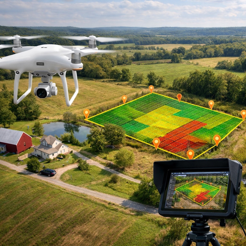
Drone surveying changes everything. A surveyor can fly a DJI drone over a property in a fraction of the time, capturing thousands of data points automatically. The drone takes hundreds or thousands of overlapping photos from different angles. Special software then processes these images to create detailed 3D maps, elevation models, and accurate measurements of the entire area.
The process starts with planning the flight. Using mapping software, the surveyor sets up a flight path that covers the entire property with enough overlap between photos. Modern DJI drones can fly these paths automatically, following GPS waypoints while maintaining the correct altitude and camera angle.
As the drone flies, it captures photos at regular intervals. A survey of even a large property might only take 20 to 40 minutes of flight time. The drone's GPS tags each photo with its exact location, which is critical for accuracy.
After the flight, the photos go into processing software that uses a technique called photogrammetry. This software analyzes how the same features appear in multiple photos from different angles and uses that information to calculate the 3D position of every visible point. The result is a detailed 3D model of the entire property, complete with accurate elevation data.
The data from a drone survey is incredibly versatile. Surveyors can create traditional topographic maps showing elevation contours. They can generate orthomosaic maps, which are like aerial photographs but geometrically corrected so that measurements are accurate. They can produce 3D models that clients can explore from any angle. And they can extract measurements like distances, areas, volumes, and slopes directly from the data.
This is valuable for many applications. Real estate developers use drone surveys to plan new subdivisions. Engineers use them to design roads and drainage systems. Environmental consultants use them to assess land conditions and monitor changes over time. Construction companies use them to calculate cut and fill volumes for earthwork projects.
One question people always ask is: how accurate is drone surveying? The answer is: very accurate, often within just a few centimeters. This is precise enough for most planning and design work. For projects that need survey-grade accuracy, surveyors can place ground control points at known locations before the drone flight. These reference points help the processing software achieve even greater precision.
The accuracy also depends on the drone and camera quality. Professional DJI drones like the Mavic 4 Pro and Phantom series have high-resolution cameras that capture the detail needed for precise measurements. The better the camera and GPS system, the more accurate the final survey.
Beyond speed and accuracy, drones make surveying safer. Surveyors don't need to walk through dangerous terrain, cross busy roads, or climb steep slopes. They can survey sites with hazards like unstable ground, standing water, or aggressive wildlife without putting anyone at risk.
Drones also make it possible to survey areas that were previously very difficult to access. Steep ravines, dense forests, and large properties in remote locations all become much easier to map when you can do it from the air.
While DJI drones represent an upfront investment, they save significant money over time. A survey that might have required a crew of three people working for several days can now be done by one person with a drone in a few hours. This means lower costs for clients and the ability to take on more projects.
The time savings also mean surveyors can deliver results faster. In many cases, clients can have preliminary data the same day as the flight, with final processed deliverables within a day or two. This speed helps keep projects moving forward without delays.
Several DJI drones excel at surveying work. The DJI Mavic 4 Pro offers an excellent combination of portability, camera quality, and flight time. Its 20-megapixel camera captures plenty of detail, and its compact size makes it easy to transport to remote sites.
For larger projects or professional surveying firms, the Phantom series and Matrice drones provide even higher accuracy and reliability. These drones can carry advanced cameras and integrate with professional surveying equipment for the most demanding applications.
The DJI Air 3S is another solid choice for surveyors who want quality results at a more accessible price point. Its dual cameras and good flight time make it capable of handling many surveying tasks effectively.
Whether you're a professional surveyor looking to modernize your toolkit or a property owner who needs an accurate survey, DJI drones offer the precision and efficiency you need. Explore the options that fit your specific surveying requirements.
See DJI Mavic 4 ProDrone surveying isn't just for traditional property surveys. The same technology helps with mine planning and volume calculations, agricultural field mapping, archaeological site documentation, environmental monitoring, and infrastructure inspection. Any time you need accurate measurements of land features, a drone survey can help.
The technology keeps improving. Newer drones have better cameras, more precise GPS, and longer flight times. Processing software is getting faster and easier to use. And new techniques like drone-based LiDAR are pushing accuracy even further for applications that need it.
If you're interested in drone surveying, the entry point has never been more accessible. You'll need a capable drone, processing software, and some training on how to plan flights and process data. Many surveyors start with a mid-range DJI drone and basic processing software, then upgrade as they take on larger or more complex projects.
The learning curve isn't steep. Most surveyors can start producing useful survey data after just a few practice flights. Online courses and tutorials are widely available to help you master both the flying and the data processing aspects.
Drones are now a standard tool for modern surveyors, and their role will only grow. As technology advances, we'll see even more automated workflows, better accuracy, and new applications we haven't imagined yet. For anyone working in surveying, civil engineering, land development, or related fields, understanding drone surveying is becoming essential.
The combination of speed, accuracy, safety, and cost-effectiveness makes drone surveying a clear win for most applications. It's not about replacing traditional surveying entirely but about having the right tool for each job. And for many surveying tasks today, that tool is a DJI drone.