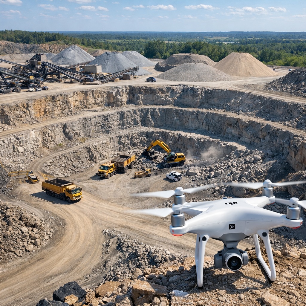
Mining and quarry operations deal with enormous quantities of material, vast work sites, and constant changes to the landscape. Accurately measuring stockpiles, tracking progress, planning operations, and maintaining safety all require detailed information about site conditions. DJI drones are transforming how mining and aggregate operations manage these challenges, providing accurate data quickly and safely while reducing costs compared to traditional surveying methods.
Knowing exactly how much material you have is fundamental to mining and quarry operations. Stockpiles of ore, aggregate, overburden, or processed material represent significant value, and accurate measurements matter for inventory management, billing customers, financial reporting, and production planning. Traditional methods of measuring these stockpiles are time-consuming, potentially dangerous, and often inaccurate.
The old approach typically involved someone climbing on stockpiles with measuring equipment to take readings at various points, then using those measurements to estimate total volume. This process puts workers at risk from unstable material, takes considerable time, and provides only rough approximations based on limited data points. The measurements might happen monthly or quarterly because of the time and expense involved, meaning operators often work with outdated information.
Drones solve this problem elegantly. A drone can fly over a stockpile in minutes, capturing hundreds or thousands of data points that processing software uses to create an accurate 3D model. The software calculates volume to a high degree of precision, far exceeding what's possible with manual methods. These surveys can happen weekly or even daily because they're quick and don't require workers to access potentially hazardous areas.
The drone flies a programmed pattern over the stockpile or excavation area, taking overlapping photos from multiple angles. Each photo is GPS-tagged with precise location data. Processing software analyzes these images, identifies common points across multiple photos, and calculates the three-dimensional position of every visible surface point. The result is a detailed 3D model of the terrain or stockpile.
From this model, the software can calculate volumes by comparing the current surface to a baseline elevation. For stockpiles sitting on flat ground, the baseline is simple. For excavations or more complex sites, the baseline might be the original pre-mining surface or a previous survey. The software accounts for slopes, irregular shapes, and varying densities to provide accurate volume calculations.
The accuracy achievable with drone surveys often surprises people new to the technology. With proper ground control points and good survey technique, volume measurements can be accurate to within one or two percent. This level of precision meets or exceeds what's needed for most mining and quarry applications, including regulatory reporting and customer billing.
Beyond stockpile measurements, drones create comprehensive maps of entire mining and quarry operations. These high-resolution aerial maps show the current state of excavations, the location of equipment and infrastructure, access roads, drainage patterns, and the relationship between different operational areas. Having an up-to-date map of the site supports better planning and decision-making at every level.
Mine planners use these maps to design future excavation phases, plan haul roads, and position equipment efficiently. Operations managers use them to track progress against plans and identify bottlenecks or inefficiencies. Safety teams use them to assess site conditions and ensure proper protocols are being followed. Environmental staff use them to monitor compliance with permits and regulations.
The ability to create these maps frequently—weekly or monthly rather than annually—means operations management is based on current conditions rather than outdated information. When site conditions change rapidly, having recent aerial data helps operations adapt and respond effectively.
Mining and quarry operations involve inherent hazards. Unstable slopes, deep excavations, heavy equipment, and difficult terrain all pose risks to workers. Drones help manage these risks by enabling thorough inspections without putting people in dangerous situations.
High-wall inspections check the stability of excavation faces and identify potential rockfall hazards. These inspections traditionally required workers to approach dangerous areas or observe from limited vantage points. A drone can closely examine the entire face from multiple angles, capturing detailed imagery that geotechnical engineers can analyze for signs of instability, water infiltration, or other concerns.
Equipment inspection becomes safer and more thorough with drones. Large mining equipment, conveyors, and processing facilities can be inspected from above and from angles that are difficult to access safely. This helps maintenance teams identify issues before they cause failures or safety incidents.
Regular site surveys also document general safety compliance. Aerial imagery shows whether safety barriers are properly maintained, if hazardous areas are clearly marked, whether equipment is stored properly, and if site housekeeping standards are being met. This overview helps safety managers identify and address issues proactively.
Whether you operate a small aggregate quarry or a large mining operation, DJI drones provide the aerial intelligence needed for accurate measurements, efficient operations, and improved safety. Professional-grade drones deliver the reliability and precision that mining operations demand.
Discover DJI SolutionsMining and quarry operations need to track production accurately for internal management, customer billing, and regulatory reporting. Traditional methods rely on weighbridge data, truck counts, or periodic physical surveys. Drones add another dimension to production tracking by providing visual documentation of how much material has been moved and where it has gone.
Comparing drone surveys over time shows exactly where material has been excavated and how stockpiles have grown or shrunk. This information validates other production tracking methods and provides detailed records that support accurate reporting. When questions arise about production figures or material movements, aerial survey data provides clear documentation of what actually happened on the ground.
For operations that bill customers based on volume, drone surveys provide defensible measurements that both parties can trust. The visual evidence combined with accurate calculations reduces disputes and ensures fair billing for delivered materials.
Mining and quarry operations work under environmental permits that specify how they must manage water, vegetation, waste materials, and site restoration. Demonstrating compliance requires regular monitoring and documentation. Drones make this monitoring more comprehensive and less labor-intensive.
Water management compliance involves tracking where water flows, ensuring proper containment of mine water, and preventing unauthorized discharges. Aerial surveys clearly show drainage patterns, the status of containment structures, and whether water controls are functioning as designed. This documentation supports compliance reports and provides evidence of proper management practices.
Vegetation and habitat monitoring tracks how operations affect surrounding areas and ensures that required buffer zones are maintained. Regular aerial photography documents that vegetation screens are healthy, that operations stay within permitted boundaries, and that progressive restoration is proceeding according to permit requirements.
When it comes time for final site closure and reclamation, baseline drone surveys provide clear records of pre-mining conditions and documentation of all operational phases. This information supports effective closure planning and demonstrates to regulators that restoration has achieved the required outcomes.
Controlled blasting is fundamental to many mining and quarry operations. Planning effective blasts requires understanding the current rock face conditions, geology, and spatial relationships. Analyzing blast results helps optimize future blast designs for better fragmentation and production efficiency.
Pre-blast surveys document the condition of the rock face, help engineers position blast holes optimally, and provide baseline data for later comparison. Post-blast surveys show the resulting fragmentation, material movement, and creation of new faces for subsequent operations. Comparing before and after imagery helps blast engineers understand what worked well and what could be improved in future blasts.
The 3D models generated from drone surveys support sophisticated blast modeling software, enabling more precise calculations of required explosives, timing sequences, and expected outcomes. This leads to safer, more efficient blasting that maximizes production while minimizing issues like overblast, flyrock, or excessive ground vibration.
Large mining sites operate fleets of equipment that need to move efficiently between excavation areas, stockpiles, processing facilities, and loading points. Planning these movements and ensuring equipment is positioned optimally requires understanding the current site layout and conditions. Aerial maps from drones provide the spatial intelligence needed for effective logistics planning.
Haul road planning benefits from having accurate terrain models that show distances, grades, and optimal routes. As operations progress and the site layout changes, routes need to be adjusted. Current aerial data helps planners design efficient haul roads that minimize fuel consumption and equipment wear while maximizing productivity.
Equipment positioning decisions use aerial overview to ensure loaders, crushers, conveyors, and other equipment are located to minimize material handling and maximize efficiency. When planning to move or add equipment, having accurate current maps helps identify optimal locations and plan the logistics of equipment moves.
The investment in drone technology typically pays for itself quickly in mining and quarry operations. The cost of traditional surveying services or the labor involved in manual measurements adds up to significant expenses over time. A drone survey costs a fraction of hiring traditional surveyors and can be done more frequently for better information currency.
The time savings matter too. A traditional survey might take days and require operations to accommodate surveyors on site. A drone survey takes hours and minimally disrupts operations. The faster turnaround on survey data means decisions can be made based on current information rather than waiting for survey results.
Improved accuracy in volume measurements can reveal hundreds of thousands of dollars in material that might have been underreported with less precise methods. For operations selling aggregate or ore based on volume, this accuracy directly impacts revenue. For operations tracking material for internal purposes, better accuracy supports more informed business decisions.
Mining and quarry operations need rugged, reliable drones that can handle challenging conditions. Sites might be dusty, windy, at high altitude, or subject to extreme temperatures. The drones need to perform consistently in these environments because operations depend on having current survey data.
The DJI Mavic 4 Pro provides an excellent balance of capability and portability for many mining operations. Its high-resolution camera captures the detail needed for accurate surveys, its flight time allows covering substantial areas, and its compact size makes it practical for field use.
Larger operations or those requiring the highest precision might choose professional mapping drones with specialized sensors and longer flight times. These industrial drones provide maximum accuracy and can handle the largest sites efficiently.
Drones are becoming standard tools in modern mining and quarry operations. As the technology matures and operators gain more experience, new applications and refinements emerge. Integration with mine planning software, automated flight planning, and AI-assisted analysis are making drone surveys even more powerful and easier to implement.
For mining and aggregate operations of any size, having drone survey capability provides competitive advantages through better information, improved safety, and more efficient operations. The technology has moved from experimental to essential, and operations that haven't yet adopted it risk falling behind competitors who have embraced aerial intelligence as a fundamental business tool.