Traffic congestion costs cities billions in lost productivity, wasted fuel, and reduced quality of life. Transportation planners and traffic engineers work to understand traffic patterns, identify problem areas, and design improvements that reduce congestion and improve safety. Traditional traffic monitoring methods provide limited data from fixed sensors and manual counts. DJI drones are giving transportation professionals new tools to observe traffic comprehensively, analyze patterns from unique perspectives, and plan improvements based on detailed real-world data about how people actually use road networks.
Understanding traffic requires data. Traditional methods rely primarily on sensors embedded in roads that count vehicles, cameras at fixed locations that record traffic flow, and manual counts where workers stand with clipboards tallying vehicles at intersections. These methods provide useful information but with significant limitations.
Fixed sensors only measure traffic at specific points. They can't see what happens between sensor locations or track how traffic moves through entire corridors. Manual counts are labor-intensive, expensive, and typically limited to short time periods. They can't practically monitor traffic patterns throughout the day or across multiple days. Camera systems provide visual records but from fixed perspectives that might miss important details about traffic behavior, pedestrian movements, or parking utilization.
These limitations mean traffic studies often work with incomplete information. Planners make educated guesses about traffic patterns based on limited data points. This uncertainty affects the quality of planning decisions and sometimes leads to improvements that don't solve problems as effectively as hoped because the underlying traffic patterns weren't fully understood.
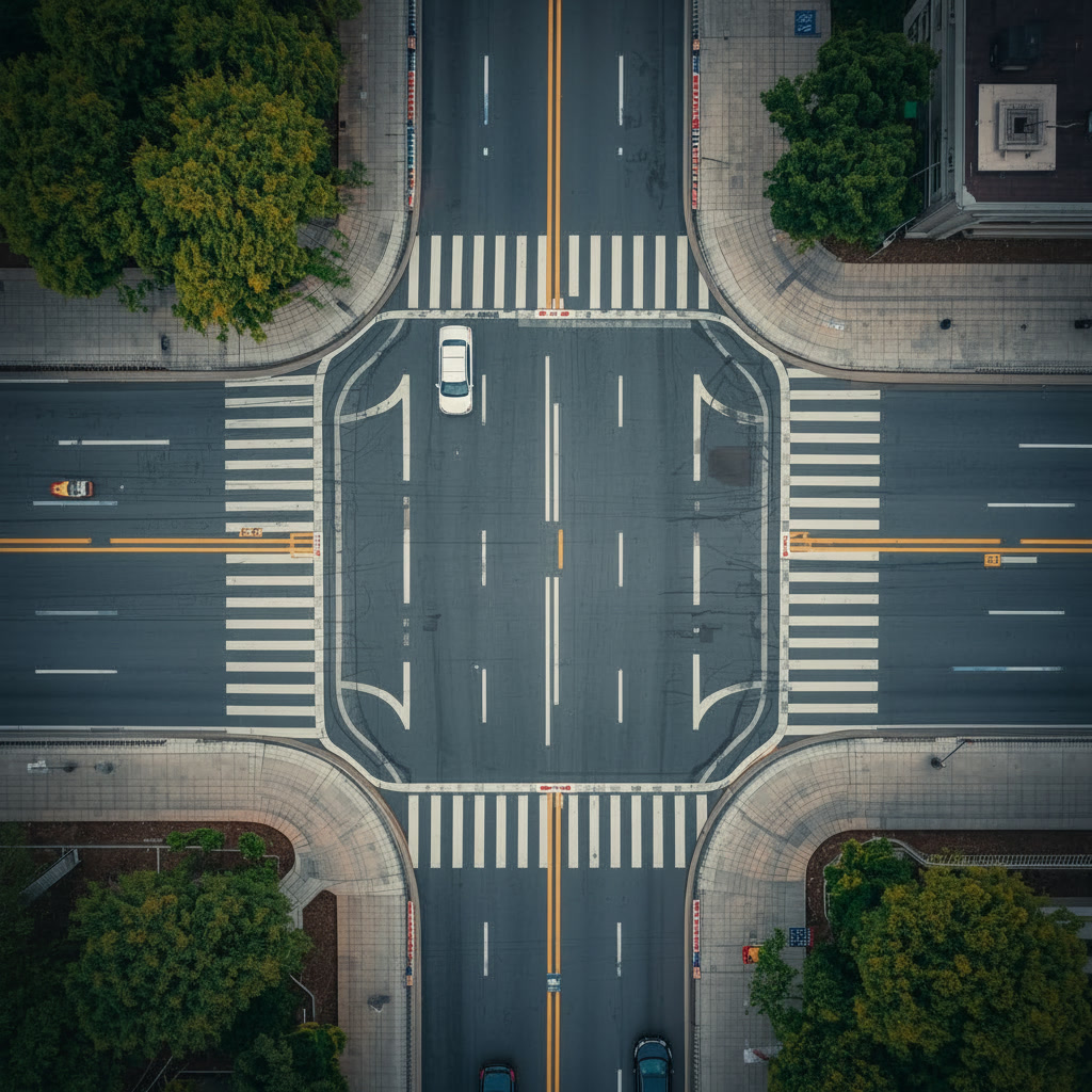
A drone flying over a busy intersection captures everything happening below. Every vehicle, every pedestrian, every turn movement, and every interaction between road users becomes visible in the aerial video. This comprehensive view reveals patterns that ground-based observation misses. Traffic planners can see how queues form and dissipate, where conflicts between vehicles and pedestrians occur, how parking influences traffic flow, and countless other details that affect road function.
The aerial perspective makes understanding complex traffic situations easier. At major intersections with multiple turn lanes, slip lanes, and pedestrian crossings, ground observation struggles to track everything simultaneously. From above, the entire intersection is visible at once. Analysts can watch recordings repeatedly, focusing on different aspects each time, extracting far more information than possible with ground observation or fixed cameras.
This comprehensive observation extends beyond single intersections. Drones can follow traffic along corridors, documenting how vehicles move through sequences of intersections, where congestion develops, and how traffic conditions vary along routes. This corridor-level understanding helps design improvements that address traffic flow as a system rather than treating each intersection in isolation.
Intersection design dramatically affects traffic flow and safety. Poor timing of traffic signals, inadequate turn lanes, confusing layouts, or insufficient pedestrian facilities can create congestion and accidents. Optimizing intersections requires detailed understanding of how they currently perform. Drones provide this understanding efficiently and comprehensively.
A drone video of an intersection during peak hours documents every relevant detail—vehicle counts for each movement, queue lengths, clearance times, pedestrian behaviors, and safety issues. Traffic engineers analyze this footage to identify problems and test potential solutions. They can measure actual traffic volumes with greater accuracy than manual counts, observe the effects of signal timing on queue lengths and delays, and identify specific movements or times when problems occur.
This detailed before-condition documentation also provides baseline data for measuring improvement effectiveness. After implementing changes—new signal timing, added turn lanes, modified geometry—follow-up drone surveys document the results. Comparing before and after conditions proves whether improvements achieved their goals and provides lessons for future projects.
Major roads often have closely-spaced intersections where traffic flows through sequences of signals. Coordinating these signals to create "green waves" where platoons of vehicles progress smoothly reduces delays and improves traffic flow. Achieving good coordination requires understanding how traffic actually moves along the corridor and how vehicles travel between intersections.
Drones can follow individual vehicles or traffic platoons along corridors, documenting actual travel patterns. This observation reveals how well current signal coordination works, where vehicles get stopped unnecessarily, and what timing adjustments might improve flow. The aerial view also shows how side streets affect corridor traffic, where merge conflicts occur, and how parking or loading activities influence through traffic.
For corridors with complex traffic patterns—multiple lanes, frequent turn movements, bus routes, bicycle facilities—the comprehensive aerial view helps planners understand interactions between different user groups and design improvements that serve everyone effectively.
Parking significantly affects urban traffic. Drivers searching for parking create congestion, circling blocks repeatedly and contributing to frustration and emissions. Understanding parking utilization helps cities manage this resource effectively—knowing when lots fill up, how long spaces remain occupied, and whether parking supply matches demand in different areas.
Traditional parking studies involve workers walking through lots and along streets, recording occupancy at specific times. This snapshot approach requires significant labor to survey large areas and provides limited information about how utilization varies throughout the day. Drone surveys offer more efficient, comprehensive parking analysis.
A drone can survey parking areas quickly, documenting occupancy across large districts in minutes. Flying the same route multiple times throughout the day tracks how parking demand varies. The imagery clearly shows not just occupancy rates but also illegal parking, parking in loading zones, accessible parking compliance, and other issues that affect parking system function.
This information helps cities make better decisions about parking policy, pricing, enforcement priorities, and where new parking might be needed or where existing parking could be converted to other uses without creating problems.
City planning departments, traffic engineering firms, and transportation agencies are finding that drones provide powerful tools for understanding and improving traffic systems. From congestion analysis to safety studies, aerial perspective enhances every aspect of transportation planning.
Explore DJI Planning SolutionsComplete streets serve all users—drivers, pedestrians, cyclists, and transit riders. Understanding how pedestrians and cyclists use streets requires observation that traditional methods handle poorly. Pedestrians don't trip sensors, manual counts of pedestrians and cyclists are labor-intensive, and understanding their movement patterns and behavior requires extensive observation.
Drones excel at documenting pedestrian and bicycle activity. The aerial view captures everyone using the street, showing where people walk, how they cross intersections, where conflicts with vehicles occur, and whether existing facilities meet user needs. This observation reveals demand for pedestrian crossings, shows whether bike lanes provide adequate separation from traffic, and identifies locations where improvements would encourage more walking and cycling.
For cities promoting active transportation, this data supports planning decisions about where to invest in sidewalks, crosswalks, bike lanes, and other facilities that make walking and cycling safer and more attractive alternatives to driving.
Traffic safety improvements depend on understanding where and why crashes occur. Crash reports provide some information, but they don't capture near-misses, risky behaviors, or conditions that contribute to crashes. Observing traffic to identify safety issues requires extensive time and doesn't capture all the relevant details.
Drone observation reveals safety issues that might not show up in crash statistics. Confusing intersections where drivers hesitate or make unexpected movements, crosswalks where pedestrians and drivers conflict frequently, merge areas where aggressive driving occurs—all these problems appear clearly in drone video even if they haven't yet resulted in reported crashes.
This proactive safety analysis identifies problems before serious crashes occur. Addressing these issues based on observed behavior patterns prevents crashes rather than waiting to react after people get hurt. The comprehensive documentation also supports safety improvement designs by showing exactly what behaviors need to be addressed.
Major events—concerts, sports games, festivals, parades—create temporary traffic challenges. Managing traffic for these events requires understanding how crowds arrive and depart, where congestion develops, and whether traffic control plans work effectively. Drones provide real-time observation during events and documentation for improving future event management.
During events, drone observation helps traffic managers respond to developing problems. If congestion builds unexpectedly, the aerial view shows where and why, allowing managers to adjust traffic control to address the issue. After events, reviewing drone footage reveals what worked well and what needs improvement for future events.
This learning process improves event traffic management over time, reducing congestion and frustration for both attendees and residents affected by event traffic.
Road construction and maintenance require work zones that reduce available road capacity. Planning these work zones to minimize traffic disruption requires understanding current traffic patterns and predicting how vehicles will respond to the temporary changes. Drones help both assess current conditions before work begins and monitor how traffic adapts to work zones once construction starts.
Pre-construction drone surveys document existing traffic patterns that will be affected by the work zone. This baseline helps predict impacts and plan detour routes. During construction, monitoring traffic through and around work zones shows whether the traffic control plan works effectively or needs adjustment to improve traffic flow and safety.
Beyond traffic analysis, drones support road infrastructure management. Regular aerial surveys document pavement conditions, identify maintenance needs, and track how road infrastructure ages and deteriorates. This information feeds into asset management systems that help cities prioritize maintenance investments and plan rehabilitation projects.
The aerial perspective also reveals drainage problems, vegetation encroachment, sign visibility issues, and other maintenance concerns that affect road function and safety. Systematic drone surveys create comprehensive records of road conditions that support better infrastructure management.
Transportation planning works better when communities understand and support proposed improvements. Drone imagery and video help communicate planning concepts to the public. Showing people aerial views of current conditions, illustrating problems that need addressing, and visualizing proposed improvements helps build understanding and support for transportation projects.
The aerial perspective is intuitive—people immediately understand what they're seeing in ways that technical diagrams or written descriptions might not convey. This improved communication helps public engagement processes work more effectively.
Compared to traditional traffic studies, drone observation provides more comprehensive data at lower cost. A few hours of drone flight produces information that might require days of manual observation or expensive specialized equipment. The reusable video records can be analyzed multiple times for different purposes, extracting maximum value from each survey flight.
For transportation agencies with limited budgets, this efficiency means better information for planning decisions without increasing study costs. More thorough traffic analysis supports better improvement designs that solve problems effectively rather than requiring additional future improvements to address remaining issues.
Transportation applications need drones with good video quality, stable flight characteristics, and adequate flight time to complete surveys. The ability to maintain position steadily while recording is important for capturing clear, useful traffic footage.
The DJI Air 3S provides excellent capabilities for traffic studies with its high-quality camera and reliable flight performance at an accessible price point. For agencies doing extensive traffic analysis, the DJI Mavic 4 Pro offers enhanced capabilities that support the most demanding applications. The key is reliable performance that produces clear, stable video suitable for detailed traffic analysis.
Drone technology in transportation planning continues advancing rapidly. Improved cameras capture better detail. Longer flight times extend survey capabilities. Artificial intelligence is beginning to automate traffic analysis, automatically counting vehicles, tracking movements, and identifying safety issues in drone footage. These advances make drone-based traffic studies even more powerful and accessible.
For transportation agencies committed to data-driven decision making, drones provide capabilities that fundamentally improve how we understand and plan transportation systems. The comprehensive observation they enable supports better designs, more effective improvements, and ultimately better-functioning transportation networks that serve communities more effectively.